
Vinkkaa tuotetta kavereillesi:
Rand McNally Folded Map: New England
Rand McNally


Rand McNally Folded Map: New England
Rand McNally
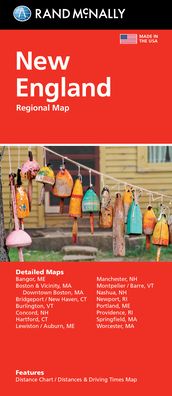
Rand McNally's folded map featuring New England is a must-have for anyone traveling in and around this part of the country, offering unbeatable accuracy and reliability at a great price. Our trusted cartography shows all Interstate, state, and county highways, along with clearly indicated points of interest, airports, county boundaries, and more. You'll see why Rand McNally folded maps have been the trusted standard for years. -Regularly updated, full-color maps. -Clearly labeled Interstate, U. S., state, and county highways. -Detail maps of major cities, a mileage chart, and a Mileages & Driving Times Map. -Indications of parks, points of interest, airports, county boundaries, and more. -Easy-to-use legend. -Detailed index. -Convenient folded size. Coverage Area Detailed maps of: Bridgeport, CT; Hartford, CT; New Haven, CT; Boston & Vicinity, MA; Boston Downtown, MA; Springfield, MA; Worcester, MA; Bangor, ME; Lewiston, ME; Portland, ME; Concord, NH; Manchester, NH; Nashua, NH; Newport, RI; Providence, RI; Burlington VT. Product Details: Measures 9.5 x 4.125 and folds out to 40 x 28.
| Media | Kirjat Map (Maa- tai merikartta) |
| Julkaisupäivämäärä | maanantai 11. lokakuuta 2021 |
| ISBN13 | 9780528025778 |
| Tuottaja | Rand McNally |
| Mitta | 100 × 234 × 10 mm · 58 g |
| Kieli | English |
Lisää tuotteita Rand McNally


Muutkin ovat ostaneet
![Cover for Preben Hansen · Turen Går Til: Turen går til Californien & Vestlige USA (Sewn Spine Book) [5. Painos] (2021)](https://imusic.b-cdn.net/images/item/original/578/9788740063578.jpg?preben-hansen-2021-turen-gaar-til-turen-gaar-til-californien-vestlige-usa-sewn-spine-book&class=scaled&v=1623395637)
![Cover for Per Jensen · Verdens mest almindelige fugl - en kærlighedserklæring til høns (Hardcover Book) [1. Painos] (2024)](https://imusic.b-cdn.net/images/item/original/012/9788794571012.jpg?per-jensen-2024-verdens-mest-almindelige-fugl-en-kaerlighedserklaering-til-hoens-hardcover-book&class=scaled&v=1717822126)
![Cover for Lise Nørgaard · Kun en pige (Paperback Book) [5. Painos] (2017)](https://imusic.b-cdn.net/images/item/original/831/9788702234831.jpg?lise-noergaard-2017-kun-en-pige-paperback-book&class=scaled&v=1492430427)


![Cover for Barry Holstun Lopez · Of Wolves and men (Paperback Book) [Revised edition] (1979)](https://imusic.b-cdn.net/images/item/original/222/9780684163222.jpg?barry-holstun-lopez-1979-of-wolves-and-men-paperback-book&class=scaled&v=1466361606)
![Cover for Lao Tsu · Tao Te Ching (Paperback Book) [1st edition] (1989)](https://imusic.b-cdn.net/images/item/original/346/9780679724346.jpg?lao-tsu-1989-tao-te-ching-paperback-book&class=scaled&v=1438694524)
![Cover for Rosamund Young · The Secret Life of Cows (Paperback Book) [Main edition] (2018)](https://imusic.b-cdn.net/images/item/original/793/9780571345793.jpg?rosamund-young-2018-the-secret-life-of-cows-paperback-book&class=scaled&v=1530148681)
![Cover for Karina Rasmussen · Hvalp i harmoni (Paperback Book) [1. Painos] (2020)](https://imusic.b-cdn.net/images/item/original/516/9788799557516.jpg?karina-rasmussen-2020-hvalp-i-harmoni-paperback-book&class=scaled&v=1585668935)
Katso kaikki joka sisältää Rand McNally ( Esim. Paperback Book , Map , Hardcover Book , Book Ja Spiral Book )